domingo, 20 de febrero de 2011

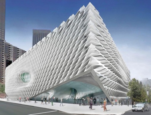
Broad Museum | Diller Scofidio + Renfro


Rem Koolhaas, Herzog & de Meuron, Christian de Portzamparc, SANAA, Diller Scofidio + Renfro y Foreign Office Architects, compitieron para el diseño del Broad Museum en los Ángeles, Estados Unidos. En Agosto se informó que el ganador del concurso fue el proyecto presentado por los norteamericanos Diller Scofidio + Renfro. 


La propuesta para el Broad Museum ha sido realizada y ya podemos observarla en su etapa de diseño final. Situado adyacentemente al Walt Disney Concert Hall de Frank Gehry’s y el Museum of Contemporary Art de Arata Isozaki, el nuevo museo se ha convertido en una parte clave de la reurbanización  para la Grand Avenue que intenta revitalizar esa vía central y darle la fuerza que ha perdido con el tiempo.

El corazón del diseño se encuentra entre dos largos bloques rectangulares. El bloque de la base sirve como estacionamientos y el bloque superior, contiene los espacios interiores para almacenamiento de obras de arte, archivos y espacios de oficina para la Fundación Broad Art.

La bóveda, el velo, y hundimientos son sólo algunos de los nombres que han sido utilizados por los arquitectos para referirse a las diferentes áreas del diseño total. Una fachada sumamente llamativa, con variadas formas hexagonales en hormigón, se eleva en la esquina formada por 2nd Street y Grand Avenue, muy cercana a el Hall de Disney, crea la entrada principal al Broad Museum.

El velo, envolviendo el espacio de la galería en el tercer piso, la bóveda en el segundo piso y el hall en el nivel de acceso, son las estructuras portantes de la carga proveniente del techo y a su vez actúan como pantalla solar para el edificio. La piel del exterior tiene transparencia y espesor variable en sus cuatro fachadas, y se sumerge en varios puntos de la cara que enfrenta a Grand Avenue, tomando la forma de ventanas hundidas.

Notablemente ausente en el diseño es la intención de permitir interacción entre los autos y el movimiento peatonal. Originalmente ésto no era así, el diseño obligaba a los conductores que se dirigían al estacionamiento a encontrarse con los peatones que accedían por Grand Avenue a través de un gran vidrio, proveyendo al proyecto de un encuentro inevitable. De todas formas, el proyecto aún está en desarrollo y se esperan variaciones con respecto al resultado final.

sábado, 19 de febrero de 2011

BIG |Greenland’s New National Gallery | Arquitectura 3d

BIG to Design Greenland’s New National Gallery

Competition-winning design for the new National Gallery of Greenland by BIG + TNT Nuuk + Ramboll Nuuk + Arkitekti
Click above image to view slideshow
Competition-winning design for the new National Gallery of Greenland by BIG + TNT Nuuk + Ramboll Nuuk + Arkitekti
Located on a steep slope overlooking the most beautiful of Greenland’s fjords, the 3,000 m2 National Gallery will serve as a cultural and architectural icon for the people of Greenland. The new museum will combine historical and contemporary art of the country in one dynamic institution The winning proposal was selected by a unanimous museum board among 6 proposals, including Norwegian Snøhetta, Finnish Heikkinen‐Komonen, Islandic Studio Granda and Greenlandic Tegnestuen Nuuk.
Visualization, Exterior
Click above image to view slideshow
Visualization, Exterior
“The Board has a clear vision: to work for the establishment of an internationally oriented highly professional institution that communicates the continuous project of documenting and developing the Greenlandic national identity through art and culture. Our dream is a national gallery where historic and contemporary art meets circumpolar pieces, Nordic and world art in general. Our dream is an institution that stimulates our curiosity, awake our excitement with its thought‐provoking design and where we all feel at home. Selecting a prominent architect as BIG, I am sure that our chances of realizing that dream are good”, Tuusi Josef Motzfeldt, Greenland’s National Gallery of Art.
Visualization, Exterior
Click above image to view slideshow
Visualization, Exterior
As a projection of a geometrically perfect circle on to the steep slope, the new gallery is conceived as a courtyard building that combines a pure geometrical layout with a sensitive adaption to the landscape. The three‐dimensional imprint of the landscape creates a protective ring around the museum’s focal point, the sculpture garden where visitors, personnel, exhibition merge with culture and nature, inside and outside.
Visualization, Exterior
Click above image to view slideshow
Visualization, Exterior
“The Danish functionalistic architecture in Nuuk is typically square boxes which ignore the unique nature of Greenland. We therefore propose a national gallery which is both physically and visually in harmony with the dramatic nature, just like life in Greenland is a symbiosis of the nature. We have created a simple, functional and symbolic shape, where the perfect circle is supplied by the local topography which creates a unique hybrid between the abstract shape and the specific location”, Bjarke Ingels, Founder and Partner, BIG.
Visualization, Exterior
Click above image to view slideshow
Visualization, Exterior
The slope opens up the sculpture garden towards the city and the view, framing both the sculpture garden and museum functions. A rough looking external façade of white concrete will patinate over time and adjust to the local weather, while the circular inner glass façade will consist of a simple and refined frame which contrasts the rough nature and compliments the beautiful view.
Visualization, Interior
Click above image to view slideshow
Visualization, Interior
” The building will with its simplistic coarseness and harmony with the landscape become a symbol of the current independent Greenlandic artistic and architectural expression.”, Andreas Klok Pedersen, Partner & Project Leader, BIG.
Visualization, Interior
Click above image to view slideshow
Visualization, Interior
The circular shape of the gallery enables a flexible division of the exhibition into different shapes and sizes, creating a unique framework for the museum’s art. Visitor access to the exhibition happens through a covered opening created by a slight lift in the façade into a lobby with a 180 degree panorama view towards the sculpture garden and the fjord as well as access to the common museum functions, including ticket counters, wardrobe, boutique and a café.
Visualization, Interior
Click above image to view slideshow
Visualization, Interior
The new gallery will create more activity at the waterfront by attracting the whole area is interconnected by a path which like the museum, forms after the shifting inclinations of the terrain. The locals and visitors will be able to admire the clear shape of the gallery which appears as a sculpture or a piece of land‐art.
Visualization, Interior
Click above image to view slideshow
Visualization, Interior
“Greenland National Gallery for Art will play a significant role for the citizens of Greenland and the inhabitants of Nuuk as a cultural, social, political, urban and architectural focal point that opens towards the city and the world through its perfect circular geometry and shape”, said Bjarke Ingels.
Model
Click above image to view slideshow
Model
Model
Click above image to view slideshow
Model
Model
Click above image to view slideshow
Model
Model
Click above image to view slideshow
Model
Model
Click above image to view slideshow
Model
Project Details:
GREENLANDS NATIONAL GALLERY OF ART
PROJECT: Greenland National Gallery
CLIENT: Nunatta Eqqumiitsulianik Saqqummersitsivia
SIZE: 3,000 m2
LOCATION: Nuuk, Greenland
COLLABORATION: TNT Nuuk, Rambøll Nuuk, Arkitekti, MIR, Glessner Group
PARTNER IN CHARGE: Bjarke Ingels, Andreas Pedersen
PROJECT LEADER: Jakob Henke
TEAM: Daniel Selensky, Ji –young Yoon, Gul Ertekin, Aleksander Tokarz, Alessio Zenaro, Johan Cool, Nicklas Antoni Rasch
Find floor plans, sections and many BIG-style diagrams in the image gallery below. All images courtesy of BIG.
East Elevation North Elevation South Elevation West Elevation Core Section Cross Section Section Unrolled Section Explosion Axo Diagram Site Plan Site Plan Satellite View Satellite View Diagram 1 Diagram 2 Diagram 3 Diagram 4 Diagram 5 Diagram 6 Diagram 7 Diagram 8 Diagram 9 Diagram 10 Diagram 11

TLS/KVA | Minneapolis Riverfront Design | Arquitectura 3d

TLS/KVA Team Wins Minneapolis Riverfront Design Competition

The bi-coastal urban and landscape design team of TLS/KVA – Tom Leader Studio (Berkeley) and Kennedy & Violich Architecture (Boston) – were named the winning team of the Minneapolis Riverfront Design Competition (MR|DC) at a press conference in Minneapolis yesterday.

The TLS/KVA team comprises 14 additional firms, including nine Minnesota partners: Kestrel Design Group, St. Paul on the Mississippi Design Center, SRF Consulting, LBG-Guyton Associates, Donjek, Economic Development Services, Mortensen Construction, Inter-Fluve, and Solid Gold.

View of RiverFIRST team proposal from the south, with the Scherer Park site in the foreground and ‘Knot Bridge’ at Plymouth Avenue.

Click above image to view slideshow
View of RiverFIRST team proposal from the south, with the Scherer Park site in the foreground and ‘Knot Bridge’ at Plymouth Avenue.
TLS/KVA was first selected as one of four finalists in November 2010, from a pool of 55 Request for Qualifications submittals representing 14 countries on five continents. The other three finalists were award-winning teams led by Ken Smith Workshop (New York City), Stoss Landscape Urbanism (Boston), and Turenscape (Beijing). The teams impressed an overflow audience at the Walker Art Center, January 27, when they presented their proposals to the public and the competition’s jury. More than 600 people attended the event in person or via live webcast; thousands more viewed the teams’ proposal videos online.
View of demonstration at Scherer Park, a 300-unit market rate housing development, restored Hall’s Island, and public beach with kayak launch.

Click above image to view slideshow
View of demonstration at Scherer Park, a 300-unit market rate housing development, restored Hall’s Island, and public beach with kayak launch.
On January 28, the MR|DC’s 14-­member jury of nationally known parks and design professionals and local decision‐makers met to evaluate the proposals. The jury’s evaluation was based on the criteria and deliverables outlined in the Competition Brief, as well as how well the proposals met the competition’s stated goals: establish parks as the economic engine for development along the river; knit communities on both sides of the riverfront to and across the river; and re‐focus Minneapolis and the region toward one of the three great rivers of the world.
View from Farview Park looking east, across new agricultural landbridge of I-94, connecting the Hawthorne neighborhood to the River.

Click above image to view slideshow
View from Farview Park looking east, across new agricultural landbridge of I-94, connecting the Hawthorne neighborhood to the River.
“Among a pool of proposals worthy of America’s fourth coast, TLS/KVA’s RIVERFIRST stood out as particularly well suited to the Upper Riverfront in Minneapolis. The team grounded their proposal in proactive outreach to the community, demonstrated extensive research, and posited several multi-­‐layered solutions unique to these 11 miles of riverfront and the habitat, communities, businesses, infrastructure, and culture intrinsic to our region,” says David Fisher, Superintendent Emeritus of the Minneapolis Park and Recreation Board and an MR|DC jury member. Fisher noted that the jury valued the participation of the other three finalists and the talent and effort represented in the proposals they submitted.
View from new Lowry Ave bridge looking south along new bluffs and ravines to the east, and Biohaven floating habitat islands to the west.

Click above image to view slideshow
View from new Lowry Ave bridge looking south along new bluffs and ravines to the east, and Biohaven floating habitat islands to the west.
The TLS/KVA RIVERFIRST proposal offers a comprehensive remediation of the city’s storm water management system and its conceptual transformation into a system of ‘tributaries’ that are naturally cleaned with planted bio‐filtration landscapes and returned to the river. The topography of the RIVERFIRST design is guided by the dynamics of the river. Where water scours and erodes, carving design principles are used to create water remediation ravines and terrace overlooks on the North East Bluffs. Where the river deposits new material, accretive principles of design are used to mold and shape land berms for the new Park.
View from new Lowry Ave bridge looking south along new bluffs and ravines to the east, and Biohaven floating habitat islands to the west.

Click above image to view slideshow
View from new Lowry Ave bridge looking south along new bluffs and ravines to the east, and Biohaven floating habitat islands to the west.
The recovery of Northside Wetlands, and the design of storm water remediation ‘ravines’ on the North East bluffs integrate public parkland with municipal eco-infrastructure and a wide range of recreation activities. The TLS/KVA design uses site topography to reconnect the Northside’s historic Farview Park with the River, urban agriculture and new skilled jobs in a proposed River City Innovation District. The site’s sloped cross-section provides for a compact footprint for a Green Port and Green Economy Industries. Sculpted landforms enable pedestrian and bike/ski River Shore Trails to rise above existing barge terminals allowing for immediate, continuous public Riverfront access. The RIVERFIRST design for Scherer Park restores Hall’s Island with public swim/skate and kayak launching facility and provides for sustainable Housing, Live/Work Studios and an Arts Center. At Scherer Park, the river produces its own dynamic landscape of sand bars and shallow pools that shift according to winter melts, patterns of sediment deposition and river flows.
Wetlands: View from barrier islands

Click above image to view slideshow
Wetlands: View from barrier islands
Real time water monitoring from the Minnesota USGS website is made public with energy efficient, smart illumination along Knot Bridges which link the creative energy of the NE Arts District with the River City Innovation District and Downtown. Floating Biohaven Islands made of recycled water bottles anchored to existing bridge piers provide seven acres of protected riparian habitat for migrating birds and endangered wildlife. The River Talk mobile phone app and solar powered Park WiFi Network create unprecedented opportunities for local and national public education about river ecology attracting world‐class institutional, corporate and organizational partners to the Minneapolis Parks.
Green Port: View from Port building terrace

Click above image to view slideshow
Green Port: View from Port building terrace
The transition to the Minneapolis riverfront initiative With their selection as the winning team, TLS/KVA will be awarded a riverfront parks commission and become part of the Minneapolis Park and Recreation Board’s Minneapolis riverfront initiative, of which the design competition was the first phase. While the team’s RiverFIRST proposal contained many specific design schemes, no particular location, project or feature has yet been identified for development. As the design competition concludes, the Park Board and its partners will engage in a four‐month transition phase to identify next steps.
View from Lowry Bridge looking back at the City

Click above image to view slideshow
View from Lowry Bridge looking back at the City
“With the success of Minneapolis Riverfront Design Competition, the largest design competition in Minneapolis history, we’ve established that the Minneapolis Park and Recreation Board can achieve great things on behalf of the people of Minneapolis and the region,” says Jayne Miller, Superintendent of the Minneapolis Park and Recreation Board. Beginning in the 1980s, a Park Board-­‐led revitalization of the Downtown Central Riverfront leveraged private investments that resulted in nearly 10,000 retained or created jobs. “We intend to replicate that same level of results-­‐focused implementation with the next phases of our riverfront initiative.”
Scherer Park Kayak Launch

Click above image to view slideshow
Scherer Park Kayak Launch
During the transition phase, the Park Board will establish a steering committee made up of individuals and organizations with experience stewarding large-­scale, multi-­disciplinary public projects or who have a vested interest in the riverfront. The steering committee will work along several parallel tracks: organizational development; planning, design and construction; resource identification; and on-­going community engagement and two-­way communication. In June 2011, the Park Board will announce the process for the next steps in the initiative.
Aerial View of Spirit Island

Click above image to view slideshow
Aerial View of Spirit Island
“Our community – not just Minneapolis, but the region and all those who view the Mississippi River as an icon of the American heartland – has high expectations of Minneapolis parks. Our reputation as the City of Lakes helps our broader community draw visitors and residents and contributes to our region’s reputation as one of the best places to live and raise a family,” says Miller. “With our riverfront initiative, we’re well aware of our responsibility to uphold our heritage and create a parks-­centered riverfront worthy of both our great river and the people who live, work and visit it now and into the future.”
Comprehensive site plan with all proposed RiverFIRST sites: Farview Park landbridge, Wetlands & River City, Green Port, East Bluffs and Ravines, Scherer Park, Library Square Park.

Click above image to view slideshow
Comprehensive site plan with all proposed RiverFIRST sites: Farview Park landbridge, Wetlands & River City, Green Port, East Bluffs and Ravines, Scherer Park, Library Square Park.